Something I’ve always been interested in are the environmental conditions that are required for glaciers to form. Glaciers are often associated with high mountains and polar areas, and the major environmental factors that influence their existence are long-term climate trends (e.g. precipitation, average air temperatures and prevailing wind direction), latitude and altitude, and local topography (e.g. slope angle and aspect).
Some places around the world contain glacial ice (like Alaska, Norway, Canada, Switzerland and New Zealand) and some don’t. Scotland is one of the places that doesn’t, but Scotland is interesting because it almost has glaciers.
Glacial ice probably existed in the Scottish mountains up until a few thousand years ago (a previous claim that glacial ice existed in the Cairngorms as recently as the 1700s has now been discredited, see the comments on my previous blog posting ‘Scottish glaciers‘), and if the tops of the highest summits were a few tens of metres higher, and the average temperatures a few degrees cooler, then glaciers might start forming in a few select places. Scotland thus has conditions for glacier formation that are on a ‘knife-edge’ – a small nudge in environmental conditions is all it would take.
A glimpse of what Scotland might look like with glaciers is not very far away; the Folgefonna glacier in western Norway is only about 500km east of Scotland, is at the same latitude as the Orkney and Shetland islands (60°N), and its glacial ice forms at altitudes of about 1400m, the same altitude as the summit of Ben Nevis, and the ice extends to altitudes as low as 490m.
There are other places around the world that are ‘on the knife-edge’ like Scotland. Some of these places have glaciers that are very small and just hanging on to existence, or had glaciers until very recently. The past century or so has seen an atmospheric warming trend globally and these areas are often seen as good indicators of the effects of global climate trends; one of these areas is the glacial ice near to the equator, on the summits of Kilimanjaro (3.4°N) and the Rwenzori Mountains (0.23°N), but perhaps less well-known are the mountain glaciers of southern Europe at suprisingly low latitudes.
There are a few contenders for the most southerly glacier in Europe:
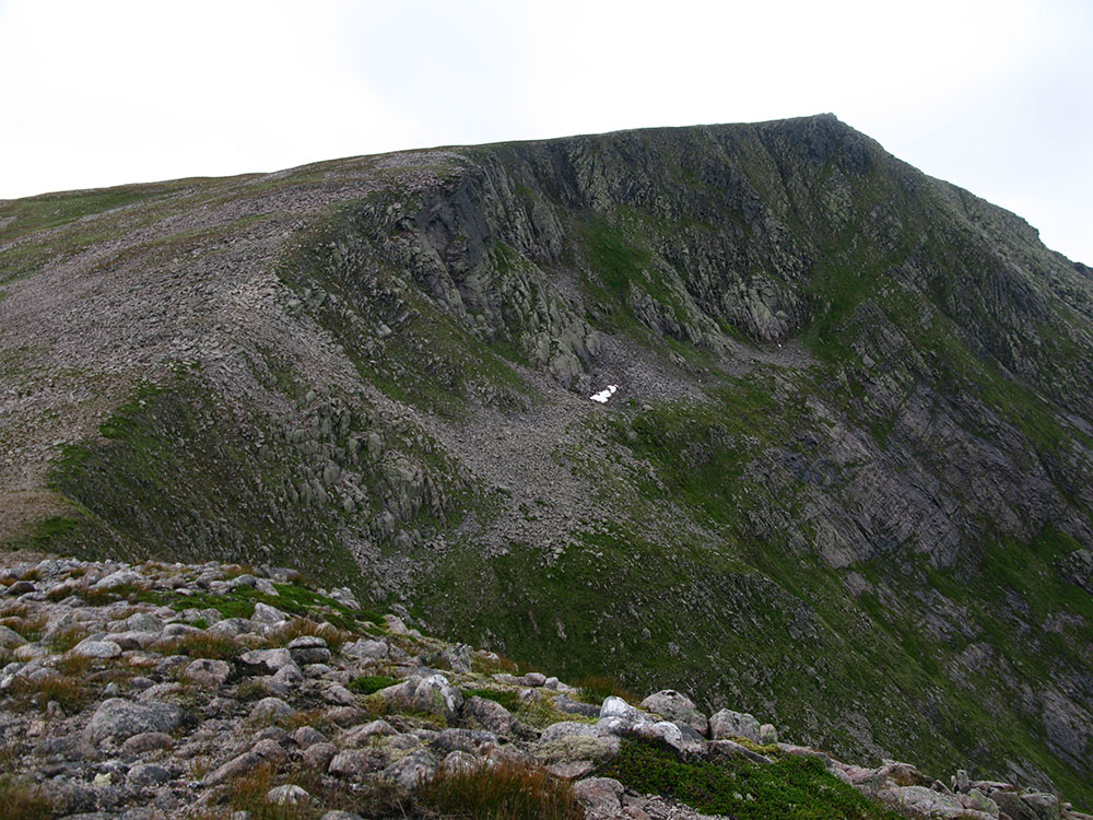
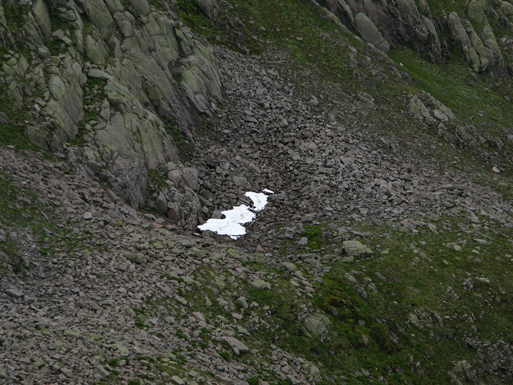
There used to be a small glacier in the Sierra Nevada mountains (37°N) of southern Spain until around the 1920s, in a northern corrie (or cirque) of its second highest-peak, Veleta (about 5km west of the highest peak Mulhacén which I climbed in 2006; see a photo of Veleta taken from Mulhacén on my website here), called Corral del Veleta, at an altitude of about 3100m. This corrie now contains Europe’s southernmost permafrost remnant and perennial snowpatches. The Sierra Nevada mountains of Spain are now on the other side of the knife-edge!
Mount Ararat in Turkey (39.42°N) and the mountains of Georgia and the Caucasus mountains (42°N) are on the edge of the generally accepted geographic borders of Europe but contain extensive ice-caps and glaciers at relatively low latitudes. Mount Medetsiz (37.3°N) in the Middle Taurus mountains of Turkey apparently has a small ‘glacier’ (see http://pubs.usgs.gov/pp/p1386g/turkey.pdf).
Of course, it’s highly debatable whether any of these sites (apart from those on Mount Ararat and in the Caucasus mountains) contain ‘glacial’ ice or are just perennial snowfields or ‘glacierets’. Here the terminology used to describe these frozen water features breaks down somewhat and other labels that are used in this context are glacier remnant, ice cap, ice sheet, névé, firn and ‘fossil’ ice.
In my view there is a continuum of physical features from small perennial snowfields (of which Scotland has several, and which I’ve described extensively in previous blog postings, see my website pages about this here) all the way to full-scale glaciers like the Aletsch Glacier in Switzerland.
At what point in this continuum of features you start using the word ‘glacier’ to describe a particular feature isn’t all that obvious, but a common definition of glacial ice is that it is composed of many years of successive snowfall layers compressed and deformed into a particular form of ice, and that this ice ‘flows’ (often described as ‘active’ or ‘dynamic’) under the force of gravity.
A fascinating academic paper (‘Europe’s southernmost glaciers: response and adaptation to climate change’) that covers this topic in great detail can be found at http://www.igsoc.org/journal/56/195/j09j048.pdf.
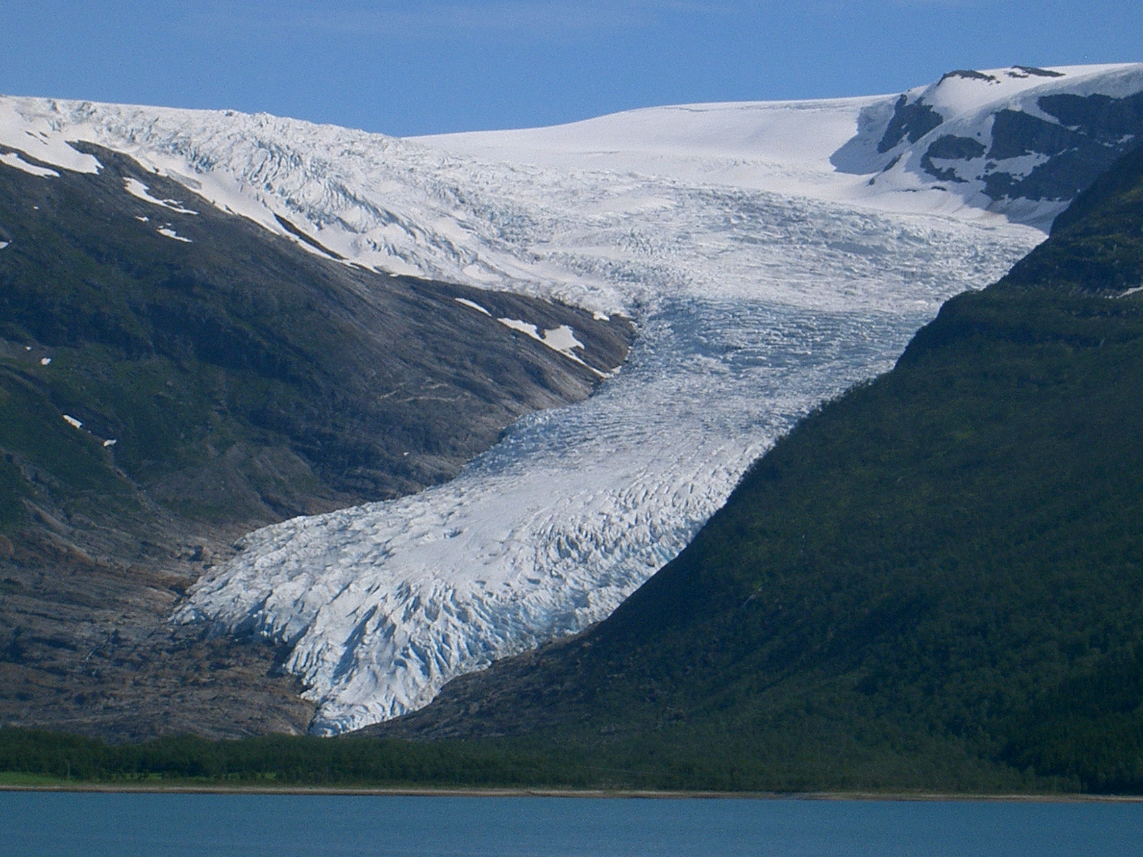
Surprisingly, glacial ice exists in Europe at altitudes almost as low as sea level. Engabreen, an outlet glacier of the Svartisen ice cap is at a latitude of 66°N and although at a relatively high European latitude in western Norway, this glacier is only just inside the arctic circle. You can see a picture here that shows how low the ice flows to. The tongue of the glacier was only 10m above sea level in 2001 (see http://www.igsoc.org/annals/50/50/a50a052.pdf) but has retreated significantly since then (see http://glacierchange.wordpress.com/2010/09/12/engabreen-glacier-norway-retreat/).
The Jökulsárlón lake in Iceland (64°N, outside the arctic circle) is at sea level and contains glacial ice that has broken off from the Breiðamerkurjökull glacier.
Outside Europe, another area of surprising glacial ice extent are the southern hemisphere Fox and Franz Jozef glaciers in New Zealand (43°S) which descend to altitudes below 300m.
Another ‘knife-edge’ place is Japan. Japan contains no ‘active’ glaciers but does contain many perennial snowpatches and at least one ‘fossil ice’ location. This is the 1000+ years old Kuranosuke snowfield at an altitude of 2700m on Mount Tate (or Tateyama) (36°N) in the Japanese Alps (described in an academic paper at http://www.igsoc.org/annals/9/igs_annals_vol09_year1987_pg218-220.pdf). You can see a good photo of the snowpatch here.
Another feature related to ‘knife-edge’ glaciers are ice caves – see my previous blog posting ‘Summer ice in rock fissures and caves‘).
Taking all of the above into account, one can imagine the existence of a notional ‘envelope’ or ‘surface’ around the Earth which would form the boundary layer at which glacial ice could exist, and which would be a function of both latitude and altitude (although of course other environmental factors such as climate and topography would affect the shape of this envelope locally; the Gulf Stream would affect it significantly in the case of Scotland). Places on the Earth’s surface where the real topographic surface intersects with this notional surface are areas that have environmental conditions that are marginal for the existence of glacial ice. This is the ‘knife-edge’.
This surface would cover the entire earth, and at the equator would be about 6000m above sea level (the altitude of the summit of Kilimanjaro), at the latitude of southern Europe (37-43°N) would be about 2300-2700m above sea level (and potentially much lower in some circumstances as shown by the Fox and Franz Josef glaciers in New Zealand), at the latitude of Bergen in western Norway (near Folgefonna) it would be about 500-1400m above sea level, dropping to sea level at about the latitude of the arctic circle (66°N).
At the latitudes of the highest Scottish mountains (56-57°N), this surface would tantalisingly come close to the highest points of Ben Nevis (1344m) and Ben Macdui (1309m). For an interesting comparison, the Torngat mountains (58°N) in Labrador in eastern Canada are on a similar latitude to the mountains of Scotland and contain summits of similar altitude at about 1500m. This location has the most southerly glacial ice on the eastern half of the continent of North America and there are many small glaciers in these mountains. One, Superguksoak Glacier, extends to an altitude as low as 650m (see http://www.igsoc.org/journal/32/112/igs_journal_vol32_issue112_pg350-354.pdf and http://cgrg.geog.uvic.ca/abstracts/BellGlacierCirque.html).
On the western side of North America, Bear Glacier in British Columbia is at the same latitude at the Scottish mountains (56°N), and extends as low as an altitude of about 600m (although the icefield where the glacial ice is initially formed lies much higher, at an altitude of about 2000m). This part of British Columbia has a maritime climate similar to western Europe, and the glacier is only about 150km from the Pacific Ocean, making the comparison with Scotland stronger.
Colorado in the central United States can also be considered a ‘knife-edge’ location. Despite the state containing some of the highest summits in the Rocky Mountains, it perhaps surprisingly only has small glaciers (there are only 7 larger than 0.1km2 in area), due to its low latitude (40°N), and perhaps also due to its relatively low levels of precipitation in the form of snow. You can find out more about the glaciers in Colorado here.
Saint Mary’s glacier (39.8°N) at an altitude of 3000m to the east of James Peak in Colorado (in reality a ‘glacieret’ or large perennial snowpatch) offers a glimpse of the kind of ice feature that could potentially form in the Scottish mountains with only a very small change in environmental conditions (see a photo of Saint Mary’s glacier here).
The most southerly glacial ice in the whole North American continent is probably on Popocatepetl (19.0°N) in Mexico, although more southerly northern hemisphere glacial ice exists on the Nevado del Ruiz volcano (4.9°N) in Colombia at an altitude of about 4,800–4,900m (much lower than the summit of Kilimanjaro which lies at a similar latitude).
The chances of an ice feature that could be described as a ‘glacier’ forming in the Scottish mountains anytime in the next century are almost certainly effectively zero (given the current climate trend forecasts), but in my view I don’t think the same can be said for ‘glacierets’.
More details and information about ‘knife-edge’ glaciers in other locations around the world can be found in Professor Graham Cogley‘s entries on the environmentalresearchweb blog, particularly these entries:


