Something I’ve always been interested in are the environmental conditions that are required for glaciers to form. Glaciers are often associated with high mountains and polar areas, and the major environmental factors that influence their existence are long-term climate trends (e.g. precipitation, average air temperatures and prevailing wind direction), latitude and altitude, and local topography (e.g. slope angle and aspect).
Some places around the world contain glacial ice (like Alaska, Norway, Canada, Switzerland and New Zealand) and some don’t. Scotland is one of the places that doesn’t, but Scotland is interesting because it almost has glaciers.
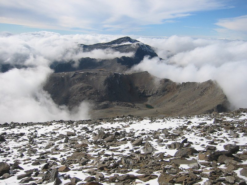
Glacial ice probably existed in the Scottish mountains up until a few thousand years ago (a previous claim that glacial ice existed in the Cairngorms as recently as the 1700s has now been discredited, see the comments on my previous blog posting ‘Scottish glaciers‘), and if the tops of the highest summits were a few tens of metres higher, and the average temperatures a few degrees cooler, then glaciers might start forming in a few select places. Scotland thus has conditions for glacier formation that are on a ‘knife-edge’ – a small nudge in environmental conditions is all it would take.
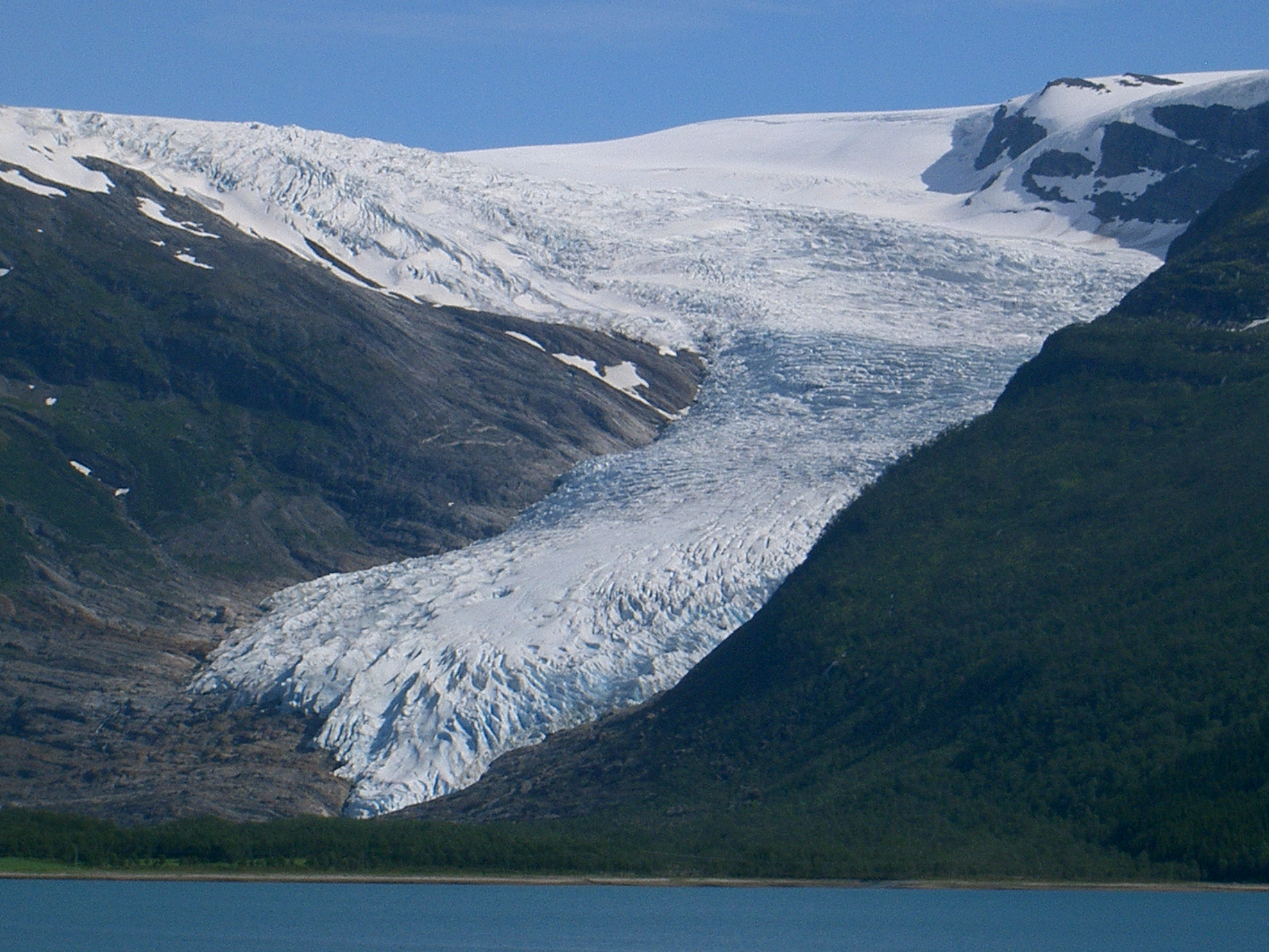
A glimpse of what Scotland might look like with glaciers is not very far away; the Folgefonna glacier in western Norway is only about 500km east of Scotland, is at the same latitude as the Orkney and Shetland islands (60°N), and its glacial ice forms at altitudes of about 1400m, the same altitude as the summit of Ben Nevis, and the ice extends to altitudes as low as 490m.
There are other places around the world that are ‘on the knife-edge’ like Scotland. Some of these places have glaciers that are very small and just hanging on to existence, or had glaciers until very recently. The past century or so has seen an atmospheric warming trend globally and these areas are often seen as good indicators of the effects of global climate trends; one of these areas is the glacial ice near to the equator, on the summits of Kilimanjaro (3.4°N) and the Rwenzori Mountains (0.23°N), but perhaps less well-known are the mountain glaciers of southern Europe at suprisingly low latitudes.
There are a few contenders for the most southerly glacier in Europe:
- The Debeli Namet glacier at an altitude of about 2100-2200m in the Durmitor Massif of Montenegro (43.06°N)
- The Calderone Glacier at an altitude of about 2680m in the Apennine Mountains of Italy (42.28°N). (there is an interesting feature that is a little bit further south in Italy than the Calderone ‘glacier’, it’s a hole full of old compacted snow on Mt. Amarao (42.1°N) at an altitude of 2795m, see http://nuke.ilcalderone.biz/Home/home_en/TheglacieretinthepotholeofMtAmaro/tabid/101/Default.aspx)
- Small unnamed glaciers at an altutude of about 2000m on Maja Jezercë in the Prokletije range in Albania (42.26°N)
- Snezhnika glacieret at an altitude of about 2450m on Vihren in the Pirin mountains of Bulgaria (41.46°N), see a picture here
There used to be a small glacier in the Sierra Nevada mountains (37°N) of southern Spain until around the 1920s, in a northern corrie (or cirque) of its second highest-peak, Veleta (about 5km west of the highest peak Mulhacén which I climbed in 2006; see a photo of Veleta taken from Mulhacén on my website here), called Corral del Veleta, at an altitude of about 3100m. This corrie now contains Europe’s southernmost permafrost remnant and perennial snowpatches. The Sierra Nevada mountains of Spain are now on the other side of the knife-edge!
Mount Ararat in Turkey (39.42°N) and the mountains of Georgia and the Caucasus mountains (42°N) are on the edge of the generally accepted geographic borders of Europe but contain extensive ice-caps and glaciers at relatively low latitudes. Mount Medetsiz (37.3°N) in the Middle Taurus mountains of Turkey apparently has a small ‘glacier’ (see http://pubs.usgs.gov/pp/p1386g/turkey.pdf).
Of course, it’s highly debatable whether any of these sites (apart from those on Mount Ararat and in the Caucasus mountains) contain ‘glacial’ ice or are just perennial snowfields or ‘glacierets’. Here the terminology used to describe these frozen water features breaks down somewhat and other labels that are used in this context are glacier remnant, ice cap, ice sheet, névé, firn and ‘fossil’ ice.
In my view there is a continuum of physical features from small perennial snowfields (of which Scotland has several, and which I’ve described extensively in previous blog postings, see my website pages about this here) all the way to full-scale glaciers like the Aletsch Glacier in Switzerland.
At what point in this continuum of features you start using the word ‘glacier’ to describe a particular feature isn’t all that obvious, but a common definition of glacial ice is that it is composed of many years of successive snowfall layers compressed and deformed into a particular form of ice, and that this ice ‘flows’ (often described as ‘active’ or ‘dynamic’) under the force of gravity.
A fascinating academic paper (‘Europe’s southernmost glaciers: response and adaptation to climate change’) that covers this topic in great detail can be found at http://www.igsoc.org/journal/56/195/j09j048.pdf.
Surprisingly, glacial ice exists in Europe at altitudes almost as low as sea level. Engabreen, an outlet glacier of the Svartisen ice cap is at a latitude of 66°N and although at a relatively high European latitude in western Norway, this glacier is only just inside the arctic circle. You can see a picture here that shows how low the ice flows to. The tongue of the glacier was only 10m above sea level in 2001 (see http://www.igsoc.org/annals/50/50/a50a052.pdf) but has retreated significantly since then (see http://glacierchange.wordpress.com/2010/09/12/engabreen-glacier-norway-retreat/).
The Jökulsárlón lake in Iceland (64°N, outside the arctic circle) is at sea level and contains glacial ice that has broken off from the Breiðamerkurjökull glacier.
Outside Europe, another area of surprising glacial ice extent are the southern hemisphere Fox and Franz Jozef glaciers in New Zealand (43°S) which descend to altitudes below 300m.
Another ‘knife-edge’ place is Japan. Japan contains no ‘active’ glaciers but does contain many perennial snowpatches and at least one ‘fossil ice’ location. This is the 1000+ years old Kuranosuke snowfield at an altitude of 2700m on Mount Tate (or Tateyama) (36°N) in the Japanese Alps (described in an academic paper at http://www.igsoc.org/annals/9/igs_annals_vol09_year1987_pg218-220.pdf). You can see a good photo of the snowpatch here.
Another feature related to ‘knife-edge’ glaciers are ice caves – see my previous blog posting ‘Summer ice in rock fissures and caves‘).
Taking all of the above into account, one can imagine the existence of a notional ‘envelope’ or ‘surface’ around the Earth which would form the boundary layer at which glacial ice could exist, and which would be a function of both latitude and altitude (although of course other environmental factors such as climate and topography would affect the shape of this envelope locally; the Gulf Stream would affect it significantly in the case of Scotland). Places on the Earth’s surface where the real topographic surface intersects with this notional surface are areas that have environmental conditions that are marginal for the existence of glacial ice. This is the ‘knife-edge’.
This surface would cover the entire earth, and at the equator would be about 6000m above sea level (the altitude of the summit of Kilimanjaro), at the latitude of southern Europe (37-43°N) would be about 2300-2700m above sea level (and potentially much lower in some circumstances as shown by the Fox and Franz Josef glaciers in New Zealand), at the latitude of Bergen in western Norway (near Folgefonna) it would be about 500-1400m above sea level, dropping to sea level at about the latitude of the arctic circle (66°N).
At the latitudes of the highest Scottish mountains (56-57°N), this surface would tantalisingly come close to the highest points of Ben Nevis (1344m) and Ben Macdui (1309m). For an interesting comparison, the Torngat mountains (58°N) in Labrador in eastern Canada are on a similar latitude to the mountains of Scotland and contain summits of similar altitude at about 1500m. This location has the most southerly glacial ice on the eastern half of the continent of North America and there are many small glaciers in these mountains. One, Superguksoak Glacier, extends to an altitude as low as 650m (see http://www.igsoc.org/journal/32/112/igs_journal_vol32_issue112_pg350-354.pdf and http://cgrg.geog.uvic.ca/abstracts/BellGlacierCirque.html).
On the western side of North America, Bear Glacier in British Columbia is at the same latitude at the Scottish mountains (56°N), and extends as low as an altitude of about 600m (although the icefield where the glacial ice is initially formed lies much higher, at an altitude of about 2000m). This part of British Columbia has a maritime climate similar to western Europe, and the glacier is only about 150km from the Pacific Ocean, making the comparison with Scotland stronger.
Colorado in the central United States can also be considered a ‘knife-edge’ location. Despite the state containing some of the highest summits in the Rocky Mountains, it perhaps surprisingly only has small glaciers (there are only 7 larger than 0.1km2 in area), due to its low latitude (40°N), and perhaps also due to its relatively low levels of precipitation in the form of snow. You can find out more about the glaciers in Colorado here.
Saint Mary’s glacier (39.8°N) at an altitude of 3000m to the east of James Peak in Colorado (in reality a ‘glacieret’ or large perennial snowpatch) offers a glimpse of the kind of ice feature that could potentially form in the Scottish mountains with only a very small change in environmental conditions (see a photo of Saint Mary’s glacier here).
The most southerly glacial ice in the whole North American continent is probably on Popocatepetl (19.0°N) in Mexico, although more southerly northern hemisphere glacial ice exists on the Nevado del Ruiz volcano (4.9°N) in Colombia at an altitude of about 4,800–4,900m (much lower than the summit of Kilimanjaro which lies at a similar latitude).
The chances of an ice feature that could be described as a ‘glacier’ forming in the Scottish mountains anytime in the next century are almost certainly effectively zero (given the current climate trend forecasts), but in my view I don’t think the same can be said for ‘glacierets’.
More details and information about ‘knife-edge’ glaciers in other locations around the world can be found in Professor Graham Cogley‘s entries on the environmentalresearchweb blog, particularly these entries:

Eddie
A term from glaciology that is relevant to this blog posting is Equilibrium Line Altitude (ELA):
http://www.fao.org/gtos/tems/variable_show.jsp?VARIABLE_ID=73
The ELA is the altitude on a glacier where the annual addition (accumulation) of mass is exactly compensated by the annual disappearance (ablation) of mass – essentially, if the calculated ELA of a part of the earth’s surface is below the altitude of the landscape surface, then glaciation may take place.
How the ELA is calculated is a big topic of research.
Eddie
In a 1949 paper, an estimate of the ‘glaciation level’ or ‘firn line’ in the range of 1450m to 1540m for the Ben Nevis area (summit 1344m) is discussed for the period of 1884 to 1903, and an estimate of 1600m for the period of 1930 to 1949. If accurate, this glaciation level is presumably significantly higher now.
However, the paper also makes the case for perennial snowpatches existing at altitudes ‘of the order of 450m below the firn line’, which accords closely with contemporary observations of perennial snowpatches in the altitude range of 1000m to 1100m in the Ben Nevis area and the Cairngorm mountains (see my website pages about these snowpatches here).
(Manley G. 1949. The Snowline in Britain. Glaciers and Climate: Geophysical and Geomorphological Essays. Geografiska Annaler 31.)
Eddie
Manley’s 1949 paper also mentions permanent snowbeds near the 882m summit of Sl�ttaratindur (62°N, about 400km north of Scotland), the highest mountain in the Faroe Islands, although this recent paper from 2003 about the periglacial environment of the Faroe Islands doesn’t seem to support this:
http://research.iarc.uaf.edu/NICOP/DVD/ICOP%202003%20Permafrost/Pdf/Chapter_026.pdf
Eddie
In an early article (1905) in Symons’s Meteorological Magazine by the Rev. R.P. Dansey, it is asserted that the high gullies to the east of the summit of Ben Nevis contain two glaciers. In the article he allows that these features are not glaciers in the sense that “they are not fed permanently by high level snows as are real glaciers” but he quotes the Rev. A. E. Robertson (the first person to complete all of the Munro summits in 1901) who says “I think also they would show glacial movement as well, so if that makes it a glacier, then I think you have it on Ben Nevis”. (Dansey, R. P. 1905. The Glacial Snow of Ben Nevis. Symons’s Meteorological Magazine 40. 29-32).
It is clear that these ‘glacial’ features described in the article are the long-lasting snowfields observed in contemporary accounts on Ben Nevis in Zero, Point Five and Observatory Gullies, and in Cool Britannia (Watson & Cameron, Paragon Publishing, 2010) mention is made of subsequent observations by Dansey and others which are more reasoned in their description of these features, even describing their complete disappearance in some years, making the case for describing them as ‘glacial’ in form, weak.
Symons’s Meteorological Magazine was founded by George James Symons in 1863, an early proponent of ‘Citizen Science’. See my blog posting ‘The new world of scientific research on the web‘.
Eddie
My statement in this blog posting that the theory that glacial ice existed in the Cairngorm mountains as recently as the ‘Little Ice Age’ period in the 17th century, has now been discredited by more recent research, is not entirely correct. See the comments in my earlier blog posting ‘Scottish Glaciers‘.
Eddie
Using observations of monthly mean temperatures and precipitation, calculations of total theoretical solar radiation, the lapse rate (the rate at which temperate changes with altitude), and the relationship between precipitation and altitude, a 1982 paper by J.G. Lockwood gives an empirically-derived altitude of 2285m for snow that lasts all year without melting, at the latitude of Britain.
(Lockwood J G. 1982. Snow and ice balance in Britain at the present time, and during the last glacial maximum and late glacial periods. Journal of Climatology 2. 209�231.)
This calculation however, ‘is for a level uniform plain with no shading of solar radiation or drifting of snow’. These local topologically-dependent factors affect this theoretical altitude greatly, and a 1975 paper by G. Manley states that because of this (and referring to empirical observations in the mountains of Norway and the Alps), the ‘firn-line’ or ‘glaciation level’ occurs at a lower level, where snow is calculated to lie for 270-280 days of the year. According to Manley, this equates to an altitude of 1400m (the altitude of the summit of Ben Nevis) for the latitude of the Scottish mountains (57-58�N), although the paper by Lockwood qoutes a higher altitude figure of ‘roughly between 1670m to 1735m’.
Manley then goes on to state that small glaciers would start to form in corries (that have an effective ‘glaciation level’ lowered by at least 150m due to drifting of snow) in the Scottish mountains if this level dropped to about 1050m, and for this to happen would require ‘a fall in the annual mean temperature of only 1.3�C’. This is a surprisingly small drop, although Manley goes on to say that for true glacial ice to form, this mean temperature drop would need to be sustained for 30-40 years. This sustained period of cool temperatures may well have occured in the Scottish mountains during the period of the ‘Little Ice Age‘. See the comments in my earlier blog posting �Scottish Glaciers�.
(Manley G. 1975. Fluctuations of snowfall and persistence of snow cover in marginal-oceanic climates. Proceedings of the WMO/IAMAP Symposium on Long-term Climatic Fluctuations. WMO No. 421. 183-188)
Interestingly, despite the orthodox scientific view that the Earth faces a warming period in the coming decades, there is some reputable scientific research from solar physics that suggests the exact opposite may happen and refers to the correlation between the periods of the the Little Ice Age and the Maunder Minimum (although as any good scientist will tell you, correlation does imply causation); although this report from the BBC Environment correspondent pours cold water on the claims:
http://www.bbc.co.uk/news/science-environment-13792479
Eddie
A good photo of the Kuranosuke snowpatch in the Japanese Alps can be seen here:
https://picasaweb.google.com/113697511198085552722/Nagano#5525303381830562466
The Hamaguri-yuki snowpatch is very close to the Kuranosuke snowpatch and is in many ways more like the snowpatches in the Scottish mountains. There is a good map of the locations of these two snowpatches here:
http://aem.asm.org/content/vol71/issue1/images/large/zam0010551280001.jpeg
The Hamaguri-yuki snowpatch is smaller than the Kuranosuke snowpatch, but lies at a similar altitude of about 2730m. It is more ephemeral in nature (it disappeared completely in 1998) and does not contain ‘fossil ice’.
An interesting paper summarises recent studies of this snowpatch and concludes that the snowpatch exists in a self-regulating stable state due to feedback mechanisms controlled by the depth and area of the snowpatch itself; hence annual temporal and spatial variations of the snowpatch are damped and the size of the snowpatch (perhaps surprisingly) is not affected to a significant degree by air temperatures in the summer months. This means that this snowpatch (and by extension, other snowpatches around the world) is not as useful an indicator of global climate change as was once thought.
(Fujita K, Hiyama K, Iida H, Ageta Y. 2010. Self-regulated fluctuations in the ablation of a snow patch over four decades. Water Resources Research 46.)
This paper is also a good model of the type of research that could be usefully carried out on the long-lasting snowpatches in the Scottish mountains.
Eddie
Another ‘knife-edge’ location is the Snowy Mountains of Australia at 36�S. Australia contains no glaciers, but it does have many long-lasting snowpatches that rarely disappear (although they all completely melted in the southern hemisphere summer of 2006/07) in the vicinity of Mount Kosciuszko in the Snowy Mountains, the highest mountain in mainland Australia at 2228m.
These snowpatches appear to have many similarities to the snowpatches in the Scottish mountains in terms of scale and situation. In a 2009 paper by K. Green and C.M. Pickering about the Snowy Mountains snowpatches, it says of the Austrialian snowpatches that ‘this provides a southern hemisphere mirror image of the situation in Scotland’.
These snowpatches are also at exactly the same latitude in the southern hemisphere as those in the Julian Alps of Japan in the northern hemisphere, and at a very similar altitude.
(Green K, Pickering C M. 2009. The decline of snowpatches in the Snowy Mountains of Australia: importance of climate warming, variable snow, and wind. Arctic, Antarctic, and Alpine Research 41. 212-218.)
Like the paper mentioned in my previous comment above about snowpatches in the Japanese Alps, this paper provides a good model of the type of research approach that could be usefully carried out on snowpatches in the Scottish mountains.
Eddie
The ELA of a glacier can be derived from statistical analysis using GIS techniques applied to the surrounding topography of the glacier, obtained from a DEM (digital elevation model) and remote sensing data, see an example of this from the paper cited below.
There are some limitations to this approach however:
- it uses the empirical observation that ELA can be calculated from the surface area of a glacier using the AAR (Accumulation Area Ratio) – this ratio is location-dependent and may not be applicable in all situations
- it is only applicable to glaciers that are already in existence and can’t be used to calculate potential ELAs for sites that may contain glaciers if environmental conditions change
- it does not into take into account local meteorological variables
(Allen T R. 1998. Topographic context of glaciers and perennial snowfields, Glacier National Park, Montana. Geomorphology 21. 207-216).
Eddie
Another ‘knife-edge’ location is the Tatra Mountains. The Tatra Mountains form part of the Carpathian mountain range, and are located along the border between Slovakia and Poland in eastern Europe.
There are no full glaciers in the Tatras, but in the ‘High Tatras’ area of the range at a latitude of 49.1�N there are are many large and perennial snowpatches. Some of these snowpatches are referred to in the academic literature as firn-ice patches or glacierets. Despite being relatively small in scale, some of these features appear to exhibit ‘active’ ice that could be described as ‘glacial’ in nature, i.e. it exhibits flow and metamorphosis under the pressure of successive annual layers of deposited snow.
One of these locations is in the Polish Tatras, in the Rybi Potok valley. The largest snowpatch here is referred to as the Mi?guszowiecki glacieret and is at an altitude of about 2000m.
(Gadek B. 2008. The problem of firn-ice patches in the Polish Tatras as an indicator of climatic fluctuations. Geographia Polonica 81. 41-52.)
The other location is in the Slovakian Tatras in the Ke�marsk� Biela voda valley. The largest snowpatch here is referred to as the Medina Kotlina glacieret. This feature is at an altitude of about 2100m and contains ‘fossil ice’ of unknown age.
(Gadek B, Kotyrba A. 2007. Contemporary and fossil metamorphic ice in Medena Kotlina (Slovak Tatras), mapped by ground-penetrating radar. Geomorphologia Slovaca et Bohemica 7. 75-81.)
Eddie
Another area that has become ‘knife-edge’ in recent decades is the Julian Alps in Slovenia. This is the location of Zeleni Snag glacier (also referred to as the Triglav glacier) at an altitude of about 2500m and a latitude of 46.2�N on Mount Triglav. This glacier has diminished significantly in size since the 1950s and is on the verge of disappearing entirely.
http://zgds.zrc-sazu.si/glasgow/7.pdf
Another smaller glacieret called the Skuta glacieret is located in the Steiner or Kamnik Alps at a latitude of 46.3�N and the relatively low altitude of about 1700m.
Eddie
The Pirin Mountains of Bulgaria contain another glacieret as well as the Snezhnika glacieret. This is the Banski suhodol glacieret which is approximately 2km to the north of Snezhnika glacieret at an altitude of about 2700m and slightly larger in surface area and volume. There are also perennial snowpatches in this area, distinct from the two glacierets.
(Gachev E, Gikov A, Zlatinova C, Blagoev B. 2009. Present state of Bulgarian glacierets. Landform Analysis 11. 16-24.
Eddie
Latest research indicates that the Prokletije Mountains of northern Albania, on the border with Montenegro, contain four separate ‘glaciers’ (although perhaps given the scale of these features, ‘glacieret’ is a better term). These are located in the same area near Maja Jezerc� at altitudes of between about 1980m and 2420m.
(Hughes P D. 2009. Twenty-first Century Glaciers and Climate in the Prokletije Mountains, Albania. Arctic, Antarctic, and Alpine Research 41. 455-459.)
Eddie
The Picos de Europa Mountains in northern Spain contain no glaciers, but latest research indicates that glaciers existed here until the early twentieth century (in a similar fashion to the Mulhac�n glacier in the Sierra Nevada Mountains of southern Spain). The Picos de Europa mountains do however currently contain 6 features referred to as ‘ice-patches’ or ‘relic ice bodies’ at a latitude of 43.1�N and altitudes of between about 2200m and 2600m. The Picos De Europa are another ‘knife-edge’ region.
(Trueba J J G, Moreno R M, Mart�nez de Pis�n E, Serrano E. 2008. ‘Little Ice Age’ glaciation and current glaciers in the Iberian Peninsula. The Holocene 18. 551-568.)
Eddie
Slightly further north than Bear Glacier in British Columbia (mentioned in the blog posting) is Brady Glacier, in the southern Alaskan panhandle. This glacier lies at 58.6�N, roughly the same latitude as the mountains in the north-western Highlands of Scotland.
This glacier lies in Glacier Bay National Park, and flows southwards into Taylor Bay. According to a website here, the ELA of the glacier lies at 800m, below the altitude of many Scottish summits. The climate in this part of North America is also strongly under the influence of a maritime climate from the nearby Pacific Ocean to the west, in a similar fashion to the climate in Scotland being strongly under the influence of a maritime climate from the nearby Atlantic Ocean to the west. The only difference between the two is the North Atlantic Current (or Gulf Stream), and this is probably a good demonstration of the overwhelming influence of the Gulf Stream on Scotland’s climate – without it, glaciers would almost certainly exist in the Scottish mountains today.
Brady Glacier is also notable in being the location of a remarkable trip made by the Scottish naturalist John Muir in 1880, in which he came close to losing his life on the glacier and which is recounted in the short autobiographical essay ‘Stickeen‘.
Kassandra
Where dogs go when they run away from home
Feel free to surf to my web page – pinterest.com (Kassandra)
Daniel Emery
Really interesting stuff – thank you for posting.
Clodoveo
Dundee University said scientists had speculated that glaciers may have re-formed in the Highlands around the time of this Little Ice Age but hard evidence has proved to be elusive.
Eddie
Not mentioned in the original posting are the ice features (or so-called ‘Eternity Glaciers’) in the Jayawijaya Mountains of Indonesia. This has become another ‘knife-edge’ area of the earth. There is a recent Guardian article about this here:
https://www.theguardian.com/world/2023/aug/25/indonesia-tropical-glaciers-melting-el-nino