Buying and Using a GPS System for Hiking
November 2006
|
For years I had thought about buying a GPS receiver, but had always been put off because I felt that buying something that just told me the coordinates of whatever position I happened to be at didn't really justify spending hundreds of pounds. I also thought that buying an electronic device for hillwalking navigation would be pointless because relying on something that uses batteries would inherently be a bad idea and in any case, I would always have to use a map and compass anyway. I thought that I would only spend money when something really useful would be available. What I wanted was a handheld GPS receiver that would have a display that showed detailed colour maps, with topographical land and road detail that would assist my driving and walking navigation in a practical way, and not just be a daft gadget. It would also have to be tough, waterproof, and have batteries that lasted at least a 2-day walking trip. It seems that finally, GPS handheld receivers like this are available, and are not prohibitively expensive. There is also mapping software available to use on these receivers that offer the detail I want. One of the first interesting mapping software products I discovered was MapSend Topo UK , which only works on Magellan GPS receivers [this product may now have been discontinued as it is now no longer listed on the Magellan website - Nov 06]. This is basically OS mapping that has been converted to a format that is suitable for use on a GPS receiver. As far as I am aware this is the only GPS mapping product that uses OS data, although there are many OS data products that are intended to be used on a PC in conjunction with a GPS receiver (for creating routes to be uploaded to the receiver, etc). I inititally though that buying a Magellan GPS receiver with this mapping software would be the ideal solution, but some reviews I read about the quality of the maps made me look more closely at the MapSend Topo maps - you can preview them on the Magellan website here . The reviews are here . From my own close inspection of these maps it seems that the coverage of unclassified roads and footpaths is not particularly accurate. This wouldn't really be much of a disadvantage if the map software was relatively cheap, but it's not. I then came across this site: http://www.smc.org.uk/ContourMaps.htm. This is a page on the Scottish Mountaineering Club website, and has free contour data for the UK available to download. This is not OS data, but data that was generated from freely available NASA public domain (Shuttle Radar Topography Mission) data. Initially I was sceptical about the quality of this data, but after reading through the site, it appeared to me that it might be a very useful thing to use for a topographical map display for hillwalking. The data also includes summit and trig point locations. While no claims are made for the accuracy of the data, you can't argue with the price! The SMC data is designed to be used on Garmin devices in conjunction with standard Garmin road maps, and this led me to look into buying a Garmin GPS receiver. I decided that the GPSMAP 60C model would be best for me [this product is now discontinued, and has been replaced by the GPSMAP 60Cx - Nov 06]. This has a rugged waterproof design, 56Mb of space for maps, a colour map display, and a large storage capability for waypoints. It uses two AA size batteries, so is not re-chargeable in the way that some other devices are (in a similar fashion to mobile phones), but I think this is a better option for hillwaking as spare batteries can always be carried easily. There is a higher-specification GPSMAP 60CS model, with an electronic barometer/altimeter and compass, but I wasn't convinced of the usefulness of these functions. The GPSMAP 60C has a GPS altitude function, and a bearing indicator, and these are all that is really required. Prices for GPS receivers seem to vary wildly. The GPSMAP 60C is currently available [Dec 05] on amazon.co.uk for £399, and £299.95 on globalpositioningsystems.co.uk. I took a risk, and bought one on eBay for £236. This price included delivery from the US. The item arrived within 4 days and was in good order - a real bargain! The receiver came pre-loaded with the Garmin european road mapping data called Mapsource Metroguide Europe, and was packaged with some Garmin PC software. Crucially however, it did not come with the mapping data CD. Because of the way Garmin receivers work, every time new map data is uploaded to the receiver, any existing data is overwritten. This meant that if I wished to upload the SMC contour data and use it alongside the Garmin road map data, I would need to have the road map data CD, which I had to buy. I also got this on eBay, for £77 including delivery (globalpositioningsystems.co.uk sell it for £99.99 plus delivery). I used the instructions on the SMC website and also those at http://www.paulmac.force9.co.uk/geo/index.html to upload the contour data to the receiver. I found I could just about get all the contour, trig point and summit data for Scotland, as well as the Garmin road data for Scotland into the 56Mb storage of the GPSMAP 60C, which I was very pleased about. I was also surprised at the contour detail and how comprehensive and generally accurate it looked. So I now had the GPS that I wanted and all that remained was to try it out.
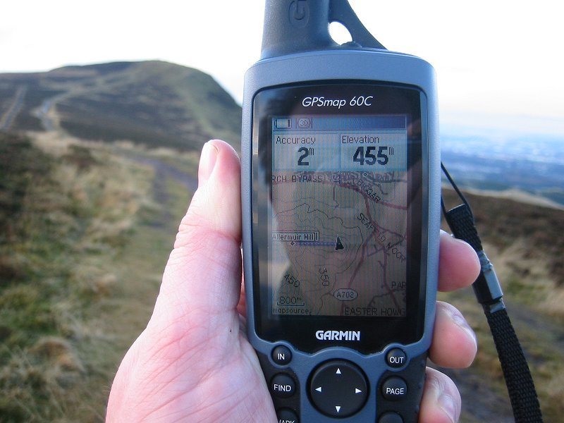
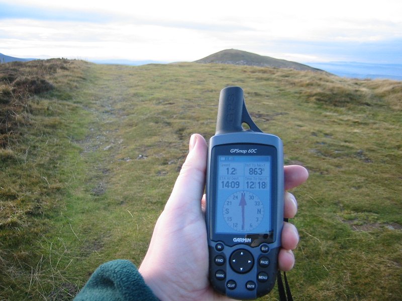
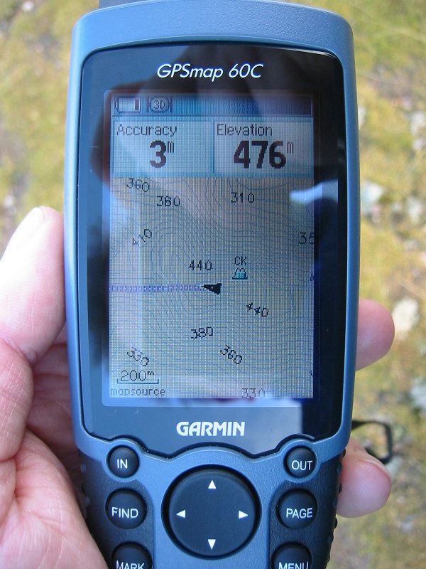
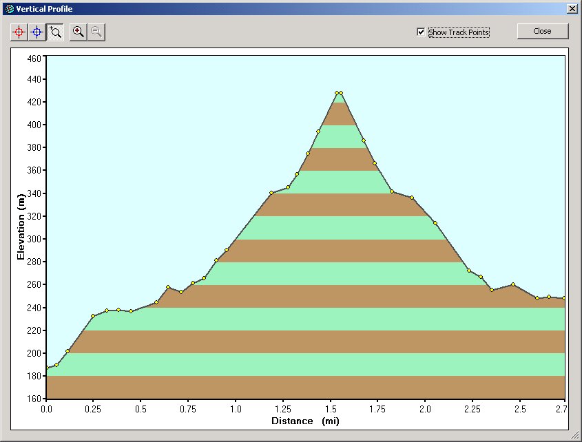
I used the GPSMAP 60C to navigate around the Pentland Hills, near Edinburgh where I live (see the photos). The screen is excellent, and easily readable in daylight. It was possible to get pretty accurate measurements (to within a few metres) of altitude and position. Navigating to a waypoint using the course indicator is quite easy to set up. The SMC contours are not as accurate as those on OS 1:50000 maps, but they are still useful for walking navigation. The ability to create a record of the route that has been walked over is useful, and the option to 'track back' along the route already walked could potentially be a life-saving facility. The route can also be imported into the Garmin Mapsource PC software, and graphical displays of the route's altitude profile can be created, like this. The GPSMAP 60C also has an odometer, so that total trip time and distance can be recorded - something I've always wanted as I've never been able to really figure out how far I've walked on some of my longer expeditions. The Garmin road maps are also very useful and the GPSMAP 60C has a facility for 'locking' on to the nearest road so that when driving, the position indicator follows the roads exactly. Battery power seems to be as indicated and two AA batteries should be adequate for a full day's constant use, although I suspect that using the GPSMAP 60C for a multi-day expedition will require replacement batteries to be carried. I also downloaded some waypoint data from http://www.archaeoptics.co.uk/archives/2005/07/16/historic-scotland-gps-waypoint-data/ . This list of waypoints contains interesting historical locations in Scotland. I needed to use the Gartrip program to change this into a format the GPSMAP 60C could use. In the future, I hope to publish some GPS measurements alongside the photos from my hillwalking trips on this site. Update Jan 2006: Garmin are also now offering an updated version of the GPSMAP 60 range of handheld receivers with an extended memory capability using 'micro' SD cards. Update Nov 2006: The upgraded successor to my GPS receiver, the GPSMAP 60Cx, is currently available from globalpositioningsystems.co.uk for £359.94 plus delivery. On eBay, the higher-spec GPSMAP 60CSx is available for £230 plus delivery. My older model is now available on eBay for around £200 plus delivery. See the GPS data I have now collected on my walking trips here. |